Early maps of Scotland provide scant information about Strathtummel, and perhaps this is not surprising as the main route northwards through the Highlands would have been the road from Perth to Inverness, passing Blair Atholl. The track running westward along Loch Tummel only led towards Rannoch moor, the home of outlaws and fugitives, and was of little interest, except in times of war and unrest.
The original track did not follow the present road past the Queen's View, but continued up Glen Fincastle and curved round to join hill-tracks from Blair Atholl and Struan, descending to meet Loch Tummel at its far end before continuing to what is now Tummelbridge. As the track reached Loch Tummel it would have passed Grennich and this is the only homestead mentioned on the Gordon maps (1636-52) or Blaeu's Atlas of Scotland (1654).
Even the building of the Wade military road southwards from Dalnacardoch to Tummelbridge, and beyond, did little to put Strathtummel 'on the map'. This route was used by the drovers who took their black cattle and sheep from the north and north-east to the markets of Comrie and Falkirk. Communications were opening up, and the new road and bridge over the River Tummel gave easier access for travellers to Stirling and Glasgow. The Tummel Bridge was built for General Wade in 1730, by John Stewart of Kynachan who was paid £200 Sterling to provide a bridge with "a single arch of at least 42 feet and a width of at least 12 feet, having easy access for wheeled carriages and cannons".
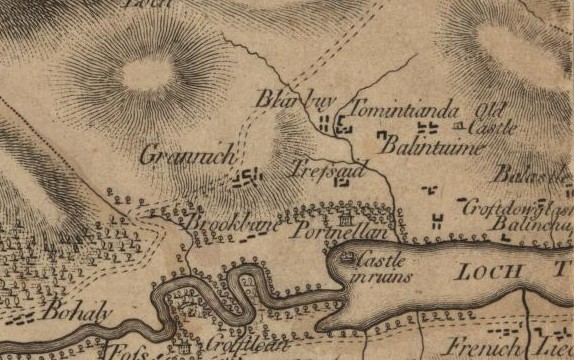
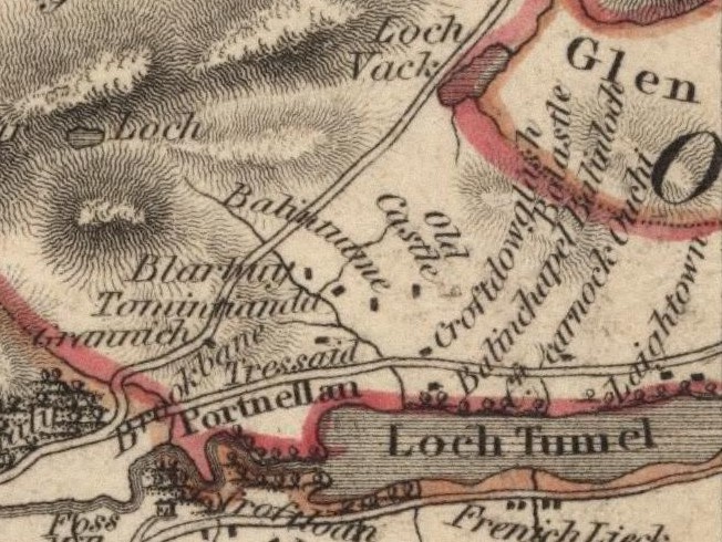
Despite this, William Roy's Military Survey of Scotland (1747-1755), only shows that there were areas of cultivation and homesteads along the north side of Strathtummel, but does not name any of them. The first map to give reliable information concerning the names of homesteads, as used in the Old Parish Records, is James Stobie's 1783 map.
On the Borenich side of Loch Tummel, the map shows: Bohally; Bruchbane; Grennich; Port-an-Eilean; Tressait; Blairbuie, which has moved southwards beside Tomintianda; Balintuim; and un-named buildings which should be Balnadodach, next to Old Castle - the so-called "ring-fort". South of this there are three un-named settlements which could be Balnauld, Chamberbane and Balnabruach. To the east of these are Balcastle; Croftdouglas (croftdowglash) and Balchapel. In addition there is an un-identified building at the lochside between Chamberbane and Croftdouglas.
It is interesting to note that the road along the north shore is not marked, although it obviously existed, and that the only road shown is crossing the hills from Grennich towards Blair Atholl.
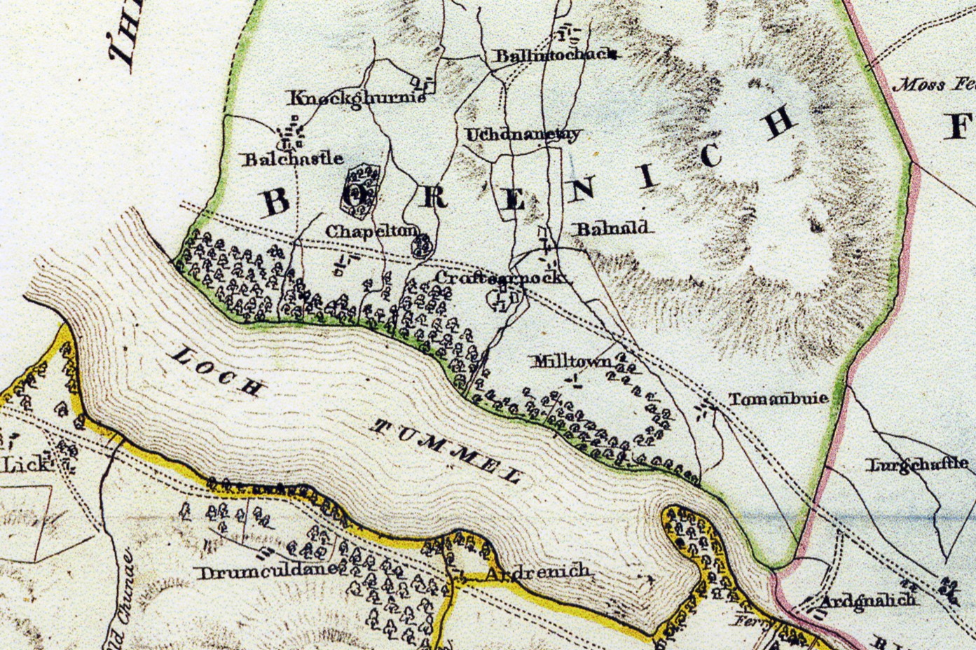
At the eastern end of Borenich the map identifies: Balintochich (Balinloch); Uchdnanetaig (Ouchinentach); Knochgarry (un-named buildings); Balnald; Croftcarnoch; Laightown (Milltown of Borenich?); and Tomanbuie.
The National Library for Scotland has James Stobie's Maps of Scotland on-line at http://www.nls.uk/maps/joins/664.html. The sections related to Strathtummel are on the right edge of the top left section of the map, and the left edge of the top right section
The next map of Borenich was produced by John Thomson in 1827.
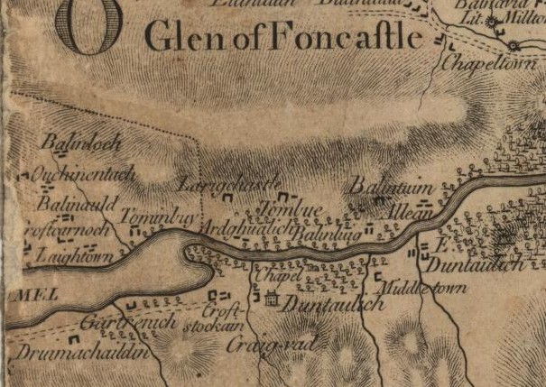
Thomson's map relies heavily upon James Stobie's work. In some cases too heavily. Although the road along the north side of Loch tummel is now shown, Thomson confuses Balnauld and Chamberbane with Croftdouglas and Balchapel. He also moves Balintochich (Balinloch) beside Balcastle, and abbreviates James Stobie's "Ouchinentach" to "Ouchi". Croftcarnoch and Laightown are also migrating westwards.
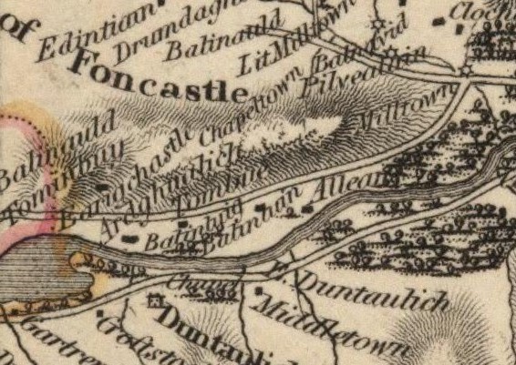
At the eastern end of Borenich the map identifies Balnald and Tomanbuie. This map also shows the road up Glen Fincastle which is interesting, as documents suggest that this was the original route to Strathtummel.
The National Library for Scotland has John Thomson's Atlas of Scotland on-line at http://www.nls.uk/maps/atlas/thomson/531.html. The sections related to Strathtummel are on the right edge of the top left section of the map, and the left edge of the top right section
The third map of Borenich is John Waterston's Reduced Plan of the Estates of Fincastle (Borenich), Lick and Duntaulich (1832)
In Waterston's map only the eastern end of Loch Tummel is shown, as the western end was owned by the Duke of Atholl. All of the homesteads appear in roughly the same place as for other maps, but Laightown now seems to be called Milltown. Waterston shows each homesteads as a group of dwellings, but this is more for effect than for an accuracate record of each building. Not until the publication of the first edition of the Ordnance Survey for Perthshire in 1867, can the position of individual buildings be matched to existing structures.
| Return to Strathtummel in Past Times | Return to Home Page |
|---|